Structural Geology
Numerical Simulation of High-Amplitude Folding
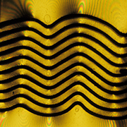
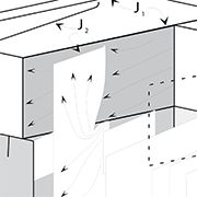
High-amplitude folding of viscous multilayers during shortening can be analyzed with a theoretical solution motivated by first-order theoretical analysis of folding by Raymond Fletcher and Ronald Smith. The solution method can better match boundary conditions along irregular interfaces than the first-order method, so it increases the range of slopes over which linear-viscous folding theory can be applied. In our method, rather than solving algebraically for a small number of constants in the flow equations, we numerically solve for a large number of constants, the values of which are chosen so that they minimize errors in matching conditions at the interfaces in a least-squares sense. A similar method has been applied to problems of density instability involving a single deformable interface with bonded contacts, however, we extend the method to include shortening parallel to interfaces and many deformable interfaces so that we can deal with problems of multilayer folding. Contacts between the layers can be firmly bonded, slip freely, or slip with viscous resistance. We use the solution to produce high-amplitude folds in single layers embedded in soft media, and in simple repetitive multilayers confined above and below by stiff or soft media. We show that the folding of linear-viscous multilayers can largely reproduce the gross forms of some small folds in the Huasna syncline in the central California Coast Range as well as the Berry-Buffalo syncline in the central Pennsylvania Appalachians. However, the sharp, chevron-like forms in these natural examples are notably missing in the simulations based on linear-viscous theory.
There are a number of simulations available. The fold program recorded the coordinates of points at each stage in the evolution of the numerical fold. These results can then be played back using a simple viewer. Sometime soon, I should get to writing a Microsoft Windows viewer (See my Programming page for any available software).
Journal of Structural Geology paper on high-amplitude folding PDF
Numerical Simulation of Duplex Structure
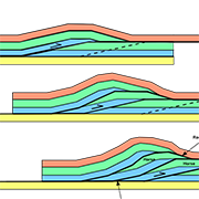
The geometry of hinterland-dipping duplex structures, produced by deformation over several successive ramp faults, can be explored using composite kinematic and mechanical models which were developed to describe the deformation in the vicinity of an isolated ramp. T he composite kinematic model permits the relationships between ramp height, angle, spacing, and displacement to be calculated. A special case of hinterland-dipping duplex structures, approximately flat-topped structures, requires a specific amount of displacement that depends on ramp angle, height, and spacing. The requirement is very sensitive to final ramp spacing, and relatively insensitive to displacement.
Some of the programs used for this work, part of my MS thesis, are available on my Programming page.
Tectonophysics paper on duplex structures PDF
Fracture Mechanics of small Joints and Faults
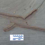
This is part of project to understand the fracturing history of the Salt Valley Anticline in Utah. The project has evolved from a detailed analysis of individual fractures, to interpreting the history of the fracture patterns over several kilometers. The work has focused on the SW limb of the anticline. The key to the project was understanding the nature of joint and fault interactions at the decimeter to meter scale
- Analysis of minor fractures associated with joints and faulted-joints - Journal of Structural Geology PDF
- Duplex structures along deformation bands in Entrada Sandstone - Journal of Structural Geology PDF
- A publication by co-workers on working out the sequence of fault development - Journal of Structural Geology PDF
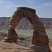
Role of Fractures in Arch Formation, Arches National Park
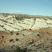
Spectacular rock fins on the flanks of Salt Valley anticline in southeast Utah are formed by erosion along zones of joints. Within a rock fin arches form where intense fracturing is localized. Fracture localization is controlled by shear displacement along existing horizontal or vertical discontinuities. Horizontal discontinuities may be shale layers, shale lenses, or bedding planes, whereas vertical discontinuities are usually pre-existing joint segments. The roof and overall shape of an arch is controlled either by existing shale layers, interfaces between sandstones of different properties, or secondary fractures due to shear on vertical joints. Joints that bound rock fins are related to the formation of the diapir-cored Salt Valley anticline. Shear displacement along existing discontinuities, which localizes intense fracturing, is probably related to the growth of Salt Valley anticline and its subsequent collapse due to dissolution of the anticlines salt core.
Geological Society of America Bulletin paper on Arch Formation PDF
Joint Patterns Networks at Arches National Park
On the southwest limb of Salt Valley Anticline are three sets of joints in the Entrada Sandstone covering an area of about 6 km2. Within the 20 m thick Moab Member, a single joint set is found in three distinct areas, separated by a second set of joints, at a 35° angle to the first. Joint interaction features show that the second set is younger than the first. This illustrates that joints of a single set do not have to fill the entire area across which the stresses that formed the joints were acting. The underlying Slickrock Member contains the third set of joints, which is at an angle of 5°-35° to joints in the Moab Member. The Slickrock set nucleated from the lower edges of joints of all orientations in the overlying Moab Member. Thus, the fracture pattern evolved both horizontally, within the same unit, and vertically between units. The sequence of jointing is determined by establishing the relative ages of each joint set. Each joint orientation is best interpreted as representing a direction of maximum compression, ruling out the possibility that the joints are a conjugate set. The joints, and an earlier set of deformation bands, record a 95° counterclockwise rotation of the direction of maximum compression.
Journal of Structural Geology paper PDF
Mobius Joints
Cross-joints which do not intersect the through-going joints confining their development are, in fact, the same joint surface as those through-going joints, as documented by three-dimensional exposures at Arches National Park.
Online Document
Forms of folds in Roseburg formation along the Umpqua River, Southern Oregon
With graduate student Carol Stack. PDF
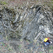
Located in a fold and thrust belt in southwestern Oregon, the folded early Eocene Umpqua Group turbidites of this study have a N-S exposure approximately 360 m long and 20 m high. Nearly a down plunge view, the exposure of short wave trains, 1 to 1½ wavelengths of 10 to 28 m, is dominated by asymmetric chevron-like folds, but includes a symmetric concentric-like fold and kink-like folds. A folding mechanism consistent with the fold and fault patterns of the outcrop is layer-parallel shortening. The form of theoretical multilayers produced in layer parallel shortening is related to the conditions of folding: contact strength of the layers, relative strength of the layers, and layer thickness. The folding units within the outcrop exhibit contrast in layer strength. The concentric-like fold is bounded above by a unit of thicker beds having relatively less shale, acting as a stiff medium in a confined multilayer since the unit thickness is greater than the wavelengths of the folds. The package of chevron-like folds does not appear to have a comparable theoretical multilayer in form. Within the kink-like fold, nonlinear slip at layer contacts, necessary in forming ideal monoclinal kink folds, may be evident in localized tan siltstone and associated calcareous nodules. Asymmetry in the outcrop, short limbs of chevron-like folds facing south and kink-like fold facing north, is consistent with the regional setting in a NNW verging thrust sheet and top-to-the-south layer-parallel shear. Top-to-the-south bedding thrusts on the long, north-dipping limbs of the chevron-like folds, and duplex-like structures in some sandstone beds are evidence of the sense of shear. Minimum shortening in the outcrop is 35 to 40 percent attributable to folding, but not including bed thickening in layer-parallel shortening and shortening in bed repetition by faulting.
The fold package appears to be in a relatively thin unit near the base of a thrust fault within a larger NNW verging thrust sheet. As a relatively thin unit bounded by muddier units above and below, there is sufficient contrast in strength over the thickness, enabling shorter wavelength folds to develop.
Analysis of a Kink-like fold in the Oregon-Idaho Graben, Malheur County, Oregon
With graduate student Jake Griffiths. PDF
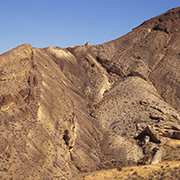
The Oregon-Idaho graben is a north-striking structural depression extending from eastern Oregon into western Idaho. During it’s evolution the graben developed a series of sub-basins, separated by north-striking intragraben fault zones. On average, intragraben fault zones have throws greater than 1 km, but are composed of individual faults with throws ranging from 1 to 10 m. Many of the faults are vertical; therefore, throw on these faults produces little shortening or extension normal to their strike. NE-striking kink-like folds are present within these fault zones. One of these faulted-kinks, here informally called the trap-door structure, is within the Dry Creek Buttes intragraben fault zone along the north shore of the Dry Creek arm of Lake Owyhee and is the topic of this thesis.
The trap-door structure was mapped at 1:3650 and a series of down-plunge views were constructed along strike. At its southern margin, the trap-door structure has dip changes greater than 35° from the regional dip; mafic sills and dikes on the western limb; sharply kinked layers in the middle; and relatively constant dip on the eastern limb, a geometry similar to Laramide folds on the Colorado Plateau. This geometry is similar along strike to the north.
The geometry of the trap-door structure is consistent with the geometry expected for deformation above the margins of sill-like intrusions or above two buried faults. However, recognizing consistent NE orientation of kink-like folds throughout the Oregon-Idaho graben, the high-angle faults, and structural evolution of the Dry Creek Buttes fault zone, displacement on buried faults is the most likely explanation for the trap-door structure. Numerical modeling and the mapped geometry indicate that a pair of NE-striking en echelon faults is buried beneath the trap-door structure. The fault-blocks are 0.24 km to 0.77 km deep, and have displacements ranging from 0.225 km to 0.320 km.
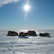
Ross Ice Shelf, Antarctica
With Dr. Christina Hulbe (University of Otago, NZ) and Dr. Ginny Catania (UT Austin)
An extensive set of shore-parallel fractures are observed at the grounding line of Kamb Ice Stream (KIS) in West Antarctica. The cracks are far more pervasive than at the nearby Whillans Ice Stream (WIS) grounding line. Fracture propagation is heard (and felt) at the KIS grounding line during the falling tide. We use field observations together with models of elastic bending and fracture propagation to establish that bending on the falling tide favors propagation while bending on the rising tide suppresses propagation, and that the combination of stresses associated with viscous deformation and tidal bending large enough to produce strand cracks close to the grounding line. Differences in basal boundary conditions across the KIS and WIS grounding line transitions (stagnant to floating vs. fast flowing to floating) are likely the cause for di erences in strand crack appearance at the two locations.